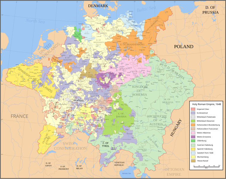
Fájl:Holy Roman Empire 1648.svg

Ennek a(z) SVG fájlnak ezen PNG formátumú előnézete: 756 × 599 képpont. További felbontások: 303 × 240 képpont | 606 × 480 képpont | 969 × 768 képpont | 1 280 × 1 015 képpont | 2 560 × 2 030 képpont | 2 283 × 1 810 képpont.
Eredeti fájl (SVG fájl, névlegesen 2 283 × 1 810 képpont, fájlméret: 3,07 MB)
Fájltörténet
Kattints egy időpontra, hogy a fájl akkori állapotát láthasd.
| Dátum/idő | Bélyegkép | Felbontás | Feltöltő | Megjegyzés | |
|---|---|---|---|---|---|
| aktuális | 2022. július 24., 21:43 |  | 2 283 × 1 810 (3,07 MB) | Maproom | ZWEIBRCKEN -> ZWEIBRÜCKEN, Treves -> Trier, Liege -> Liège |
| 2022. május 18., 18:55 |  | 2 283 × 1 810 (3,07 MB) | Maproom | Consistent, and German, spelling of "Mainz" | |
| 2021. május 25., 21:11 |  | 2 283 × 1 810 (3,07 MB) | ElCet | added the biggest city of Upper Silesia back then | |
| 2018. március 23., 12:34 |  | 2 283 × 1 810 (3,01 MB) | Valentinian | Cleanup some names including missing umlauts. Brunswick-Lüneburg -> Brunswick-Celle (see talk). Border north of Rendsburg seems slightly off to me and the situation in Holstein is rather simplified (jointly administered areas are missing). | |
| 2010. október 8., 20:09 |  | 2 283 × 1 810 (3,01 MB) | Joostik | Ravenstein as part of Cleves | |
| 2009. augusztus 9., 20:45 |  | 2 283 × 1 810 (3,01 MB) | Ysangkok | simplify code (save as plain svg) | |
| 2009. július 14., 10:24 |  | 2 283 × 1 810 (4,17 MB) | Roke~commonswiki | Zusmarshausen | |
| 2007. április 20., 16:16 |  | 2 283 × 1 810 (4,12 MB) | Roke~commonswiki | ||
| 2007. április 20., 03:04 |  | 2 283 × 1 810 (4,11 MB) | Roke~commonswiki | rm HRE text, darken labels | |
| 2007. április 18., 04:04 |  | 2 283 × 1 810 (4,11 MB) | Roke~commonswiki |
Fájlhasználat
Az alábbi lapok használják ezt a fájlt:
Globális fájlhasználat
A következő wikik használják ezt a fájlt:
- Használata itt: af.wiki.x.io
- Használata itt: azb.wiki.x.io
- Használata itt: az.wiki.x.io
- Használata itt: br.wiki.x.io
- Használata itt: ca.wiki.x.io
- Használata itt: ckb.wiki.x.io
- Használata itt: cs.wiki.x.io
- Használata itt: el.wiki.x.io
- Használata itt: en.wiki.x.io
- Peace of Westphalia
- Thirty Years' War
- Germans
- Wikipedia:WikiProject Maps
- Imperial Estate
- Talk:Paul Skalich
- Treaty of Fontainebleau (1631)
- Wikipedia:Featured picture candidates/Holy Roman Empire in 1648
- Wikipedia:Featured picture candidates/May-2007
- User talk:Giano II/archive 7
- User:Luosiji/Sandbox
- User:Jammydodger/HRE
- Germany in the early modern period
- Wikipedia talk:WikiProject Maps/Archive 5
- Territorial evolution of France
- User:Oaholroyd/sandbox
- User:JMvanDijk/Sandbox 10
- User:DyinRich/Something Else
- Aftermath of the Eighty Years' War
- User:Falcaorib/Germany and Prussia
- Használata itt: eo.wiki.x.io
- Használata itt: et.wiki.x.io
- Használata itt: fa.wiki.x.io
- Használata itt: fi.wiki.x.io
- Használata itt: fy.wiki.x.io
- Használata itt: hy.wiki.x.io
- Használata itt: id.wiki.x.io
- Használata itt: it.wiki.x.io
A fájl globális használatának megtekintése


