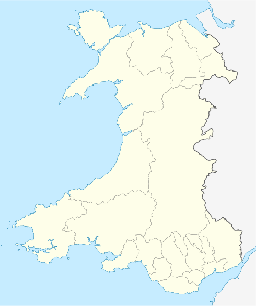
Fájl:Wales location map.svg

Ennek a(z) SVG fájlnak ezen PNG formátumú előnézete: 501 × 599 képpont. További felbontások: 201 × 240 képpont | 401 × 480 képpont | 642 × 768 képpont | 856 × 1 024 képpont | 1 713 × 2 048 képpont | 1 047 × 1 252 képpont.
Eredeti fájl (SVG fájl, névlegesen 1 047 × 1 252 képpont, fájlméret: 237 KB)
Fájltörténet
Kattints egy időpontra, hogy a fájl akkori állapotát láthasd.
| Dátum/idő | Bélyegkép | Felbontás | Feltöltő | Megjegyzés | |
|---|---|---|---|---|---|
| aktuális | 2009. június 24., 14:27 |  | 1 047 × 1 252 (237 KB) | NordNordWest | {{Information |Description= {{de|Positionskarte von Wales, Vereinigtes Königreich}} Quadratische Plattkarte, N-S-Streckung 163 %. Geographische Begrenzung der Karte: * N: 53.5° N * S: 51.3° N * W: 5.5° W * |
Fájlhasználat
Az alábbi lapok használják ezt a fájlt:
- 1 Monk Street
- 33 Whitecross Street
- A Menai-szoros függőhídja
- Aberystwythi vár
- Agincourt House
- Ancre Hill
- Baptista templom (Monmouth)
- Beaufort herceg híd
- Beaumarisi vár
- Caernarfoni vár
- Castell y Bere
- Chapel House
- Chippenham Park
- Clawdd-du
- Cornwall House
- Croft-Y-Bwla
- Deganwyi vár
- Drybridge House
- Glendower House
- Golf Halt
- Great Castle House
- Harlechi vár
- Hyam’s Mineral Water Works
- I. Eduárd király várai és városfalai Gwynedd grófságban
- Judges’ Lodgings
- King’s Head Hotel
- Little Castle House
- Market Hall
- Masonic Hall, Monmouth
- Megyei fegyház (Monmouth)
- Metodista templom (Monmouth)
- Monmouth Mayhill vasútállomás
- Monmouth Troy vasútállomás
- Monmouthi csata (1233)
- Monmouthi kereszt
- Monmouthi kolostor
- Monmouthi vár
- Monmouthi völgyhíd
- Monnow híd
- Nelson Garden
- North Parade House
- Oak House
- Old Nag’s Head
- Parade House
- Priory House
- Punch House
- Rhuddlani vár
- Rolls Hall
- Royal George Hotel
- Régi kórház (Monmouth)
- Savoy Theatre
- Shire Hall
- St. Mary-kolostortemplom
- St. Peter-templom
- St. Thomas the Martyr-templom
- St. Wonnow-templom
- Szűz Mária-templom (Monmouth)
- The Angel Hotel
- The Beaufort Arms Hotel
- The Dispensary
- The Gatehouse
- The Green Dragon
- The Griffin
- The Hendre
- The Mayhill Hotel
- The Nelson Rooms
- The Queens Head
- The Robin Hood Inn
- The Three Horseshoes
- The Vine Tree
- The White Swan Inn
- Treowen
- Troy House
- Wyastone Leys
- Sablon:Pozíciós térkép Wales
Globális fájlhasználat
A következő wikik használják ezt a fájlt:
- Használata itt: af.wiki.x.io
- Használata itt: ar.wiki.x.io
- Használata itt: ast.wiki.x.io
- Használata itt: az.wiki.x.io
- Használata itt: ba.wiki.x.io
- Használata itt: bg.wiki.x.io
- Használata itt: bh.wiki.x.io
- Használata itt: bn.wiki.x.io
- Használata itt: br.wiki.x.io
- Dolgellau
- Bangor-is-y-coed
- Aberaeron
- Patrom:Infobox UK place
- Rhaeadr Gwy
- Llanfachraeth (Mon)
- Trefor (Mon)
- Caergybi
- Aberporth
- Beulah (Ceredigion)
- Llanfihangel-yn-Nhywyn
- Abermaw
- Llan-faes (Mon)
- Ynyslas
- Clynnog Fawr
- Ffair-rhos
- Patrom:Location map Kembre
- Bont Goch
- Gilfachreda
- Parc-llyn
- Pennant (Ceredigion)
- Brongest
- Bryngwyn (Ceredigion)
- Brynafan
- Brynhoffnant
- Coed-y-bryn
- Cwmsychbant
A fájl globális használatának megtekintése
